Introducing the Mozilla Location Service

The Mozilla Location Service is an experimental pilot project to provide geolocation lookups based on publicly observable cell tower and WiFi access point information. Currently in its early stages, it already provides basic service coverage of select locations thanks to our early adopters and contributors.

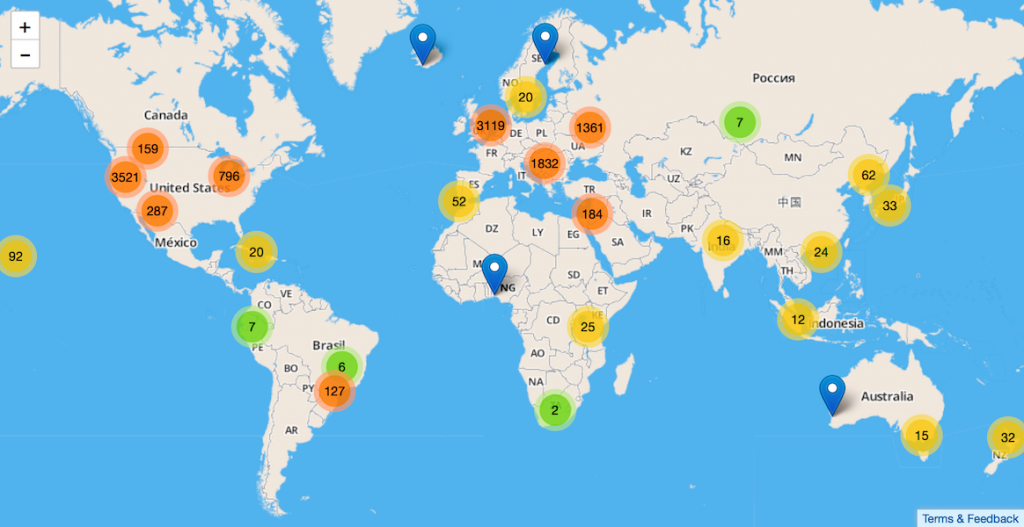
A world map showing areas with location data. Map data provided by mapbox / OpenStreetMap.

While many commercial services exist in this space, there’s currently no large public service to provide this crucial part of any mobile ecosystem. Mobile phones with a weak GPS signal and laptops without GPS hardware can use this service to quickly identify their approximate location. Even though the underlying data is based on publicly accessible signals, geolocation data is by its very nature personal and privacy sensitive. Mozilla is committed to improving the privacy aspects for all participants of this service offering.

If you want to help us build our service, you can install our dedicated Android MozStumbler and enjoy competing against others on our leaderboard or choose to contribute anonymously. The service is evolving rapidly, so expect to see a more full featured experience soon. For an overview of the current experience, you can head over to the blog of Soledad Penadés, who wrote a far better introduction than we did.

We welcome any ideas or concerns about this project and would love to hear any feedback or experience you might have. Please contact us either on our dedicated mailing list or come talk to us in our IRC room #geo on Mozilla’s IRC server.

For more information please follow the links on our project page.

Hanno Schlichting, on behalf of the geolocation and cloud services teams
11 responses

  1. Gavin wrote on :

    it’s good to hear mozilla are looking into an alternative geolocation service, i wondered if you had considered partnering with other projects like http://opensignal.com/ who are doing a similar thing tracking wifi and tower locations. they are focusing on signal quality but there is a small overlap and potential to share data

  2. Tobias wrote on :

    Have you considered cooperating with OpenWLAN Map http://www.openwlanmap.org/ ? Granted, their data set may be not that large, but every bit will help on this…

    Good Luck for your project!

  3. Hanno Schlichting wrote on :

    @Tobias, @Gavin: Yes, we have reached out to a number of existing communities and projects and are still in talks with them.

  4. Tobias wrote on :

    Then I wish all the best for the talks, as the unification of the available open (!) data under one hood with a great name is really a brilliant thing to look forward.

  5. MC wrote on :

    Opensignal is not opened, they collect the data from users but don’t share back the database ( for download) but just display maps. The truly opened databases are opencellid, openbmap, etc (see https://en.wikipedia.org/wiki/Cell_ID for a list)

    It’s many years I’m following this kind of projects and have been frustrated sometimes to collect data for projects that then were abandonned. I really hope Mozilla can built a real public and fully open project but you should definitely start integrating opencellid or openbmap databases.

    The other thing is to build a database of real tower locations. The location given by all these projects are actually virtual location, the virtual location of a center of a cell which differs from the real tower location. I was looking to put in openstreetmap the real tower locations but there’s no official tag for base stations. In Switzerland for example, there’s an official tower map but they don’t indicate the operator or cellid (see http://map.geo.admin.ch/?topic=funksender&lang=en ).

  6. Olivier wrote on :

    We need a web app for Firefox OS and Tizen imo 😉

    1. Hanno Schlichting wrote on :

      Community members have started working on FxOS apps, one effort is https://github.com/clochix/FxStumbler and another https://github.com/reinvented/getcellid.

  7. Jonas wrote on :

    What’s the difference between Mozilla Location Service and Open WLAN Map?

    1. Hanno Schlichting wrote on :

      Open WLAN Map is one of many existing projects in this space. We have a list of projects we know about at https://wiki.mozilla.org/Services/Location/Bootstrap. Both technical and license issues make it complicated to agree on the exact form of cooperation.

      In addition our project is focused on providing location services based on many different types of signals. Currently we only use WiFi access points and cell towers, but we’ll likely extend this to Bluetooth devices and IP addresses in some way. Research in this area suggests using other sensors, like ambient light sensors, barometers or the compass for the magnetic field as additional useful sources for indoor location. So far the projects we talked to where interested in gathering one type of data (like WiFi or cell towers) but not in a combined effort. In order to provide a competitive service in terms of providing accuracy/precision, using multiple sources is a must.

  8. Elmi wrote on :

    How about privacy? http://www.openwlanmap.org/ is doing something similar, seems to have more data AND they respect peoples privacy: WLANs are removed from their database automatically and owners can unsubscribe their WLAN manual too.

    Where can I find something similar at Mozilla Location Service?

    Or is it going the same way like Google, just scan, grab, trace, record, no matter what collateral damage is made?

    1. Hanno Schlichting wrote on :

      We have listed some initial ideas on privacy at https://wiki.mozilla.org/Services/Location/About. We take privacy of all involved parties seriously, but it is a complicated topic. We started listing some thoughts on a manual WiFi opt-out process at https://bugzilla.mozilla.org/show_bug.cgi?id=874916, but so far we haven’t come up with a workable and good idea.